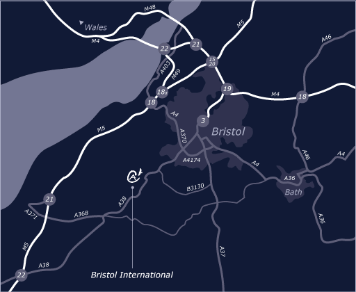
From North M5
Leave the M5 at junction 18 (signposted A4 Bristol & Airport). Take the A4 towards Bristol following signs for the airport. Go past Bristol City Football ground and connect with the A38 towards Taunton, the airport is situated 8 miles South of Bristol on the A38. Follow the A38 past the main entrance to the airport until you reach the next roundabout. Take the second exit signposted Silver Zone Parking and BFC.
From South M5
Leave the M5 at Junction 22, at roundabout take 3rd exit signposted A38. At East Brent roundabout joining the A370 take the second exit signposted A38 and airport. Continue on this road for approx 11 miles. When you reach the first airport roundabout signposted Silver Zone Parking and BFC take the first exit. You will see BFC on your right.
From South East (Bath)
Follow the A4 towards Bristol, bear left onto the A4174 signposted Ring Road. Continue to follow signs for Airport and A38 Taunton. Follow the A38 past the main entrance to the airport until you reach the next roundabout. Take the second exit signposted Silver Zone Parking and BFC. You will see BFC on your right.
By Train
The nearest train station to Bristol International Airport is Bristol Temple Meads, approximately seven miles away. The Bristol International Flyer express coach service connects you from Bristol Temple Meads to the airport every 20 minutes during the day.
By Bus
The Bristol International Flyer is the only express coach link between Bristol railway station (Temple Meads) and Bristol bus station and Bristol International Airport. There is a comfortable Flyer lounge at Temple Meads train station. The journey time is approximately 30 minutes. There is no need to pre book, simply pay on board.
Buses run from 0500 to 2310, starting at Temple Meads train station every twenty minutes.